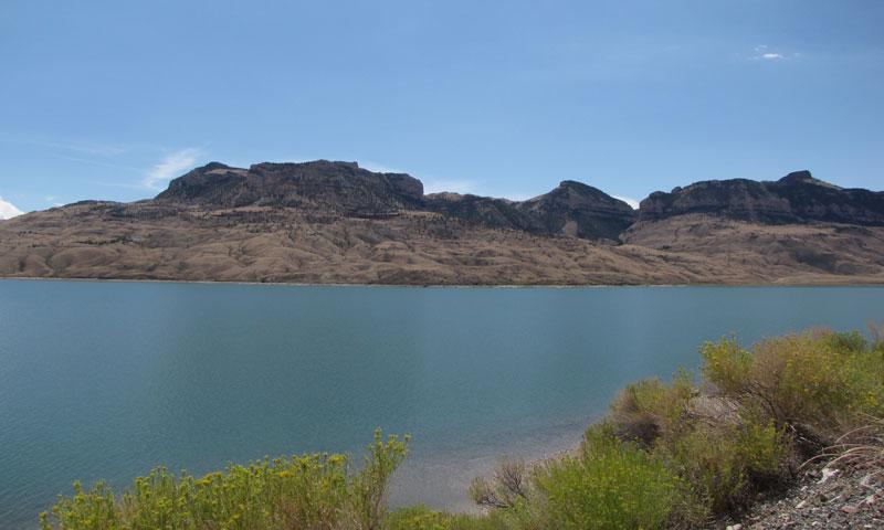
AmericInn — 210 quiet locations in 21 states - That's 210 convenient places to get a quiet, restful night's sleep. 210 spots with the complimentary AmericInn Perk Breakfast area, featuring hot waffles, fresh fruit, premium coffee and more. And 210 hotels with a large pool area where you and your family can relax at the end of a long, hard day.
Cody

Buffalo Bill State Park, Cody Wyoming

Buffalo Bill State Park

Map Weather Yellow Pages Bookmark Send to Friend Print

History

The history of Buffalo Bill Reservoir and "Cody Country" is rooted in the rich lore of the old West. Buffalo Bill State Park was named for Colonel William F. "Buffalo Bill" Cody, famous as a wild west showman, promoter and developer. He first came to the region in the 1870s as a guide for a survey expedition and spent the next 20 years guiding and sponsoring hunting parties in the area. 

"Buffalo Bill" Cody was influential in bringing irrigation and agricultural development into the area and founded the town in 1896 that bears his name. Some of the land now occupied by Buffalo Bill State Park was originally owned by Colonel Cody and was acquired from him by the federal government to implement the reservoir project. 

Work began on the dam in 1905. When completed in 1910, it was the highest dam in the world at 325 feet. Buffalo Bill State Park was established in 1957 and provided recreational areas and facilities along the original shoreline. In 1993 an eight year project was completed which raised the crest of the dam 25 feet and increased the reservoir storage capacity. The enlarged reservoir inundated the former recreation areas, which required removal of the old park facilities. Buffalo Bill State Park has been redeveloped as part of the project.

Surroundings

Mountains dominate the scenery at Buffalo Bill State Park. Shoshone Canyon, the location of the dam, is framed by Rattlesnake Mountain to the north and Cedar Mountain (also known as Spirit Mountain) to the south. Further west, along the north shoreline, lies Logan Mountain. The north and south forks of the Shoshone River are divided by Sheep Mountain while prominent on the southern skyline is Carter Mountain. All are part of the Rocky Mountain Absaroka (Ab- Sor'-ka} Range. Elevations vary from approximately 5,400 feet in the state park to over 10,000 feet in the Absarokas.

Reserve a Group Facility

Group picnic shelters are available at both Sheep Mountain and Bartlett Lane day use areas. Shreve Lodge provides an indoor setting for group functions. Trout Creek Group Camping Area, located within North Fork Campground, provides facilities for overnight use. Call park headquarters to reserve, 307-587-9227.

Fishing

Licenses are available at Game & Fish Department offices or at local selling agents (not available at Buffalo Bill State Park).

Park Fees

An annual camping permit is available for residents of Wyoming. Daily camping permits are also available for both residents and non-residents.

An annual daily use permit is available for both residents and non-residents, and valid for the holder and occupants of the holder's vehicle. Without the annual daily use permit, visitors must pay daily use fees.

- content from Wyoming Dept. of State Parks

The Buffalo Bill Historical Center in Cody, WY - A Comprehensive Look at the American West- featuring the best the west has to offer in the Western Art Museum, Natural History Museum, Plains Indian Museum, American West Research Library, and the world's most comprehensive assemblege of American arms.

Cody, WY Weather

Currently Outside
73F
Sunny. Mild.
View the Cody, WY 7 Day Forecast

Other pages you might find helpful:


Custer State Park, Black Hills SD
If you are heading here from the east, consider a stay at Custer State Park and Black Hills South Dakota.